
Travelers over Route 501 today are unaware of their crossing over the Lititz creek. Not so two centuries ago when this was the most difficult crossing on the road from Lancaster to Sheafferstown. Not only was it hard to ford the deep stream, but the swamp that extended almost to Front Street was well nigh impassable.
The increasing traffic on this road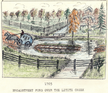 which was bringing considerable business to Lititz demanded action and the town was equal to it. An early map clearly shows how this hazard was overcome by diverting the stream around a man-made island covered with creek stones. This separated the stream into two shallow fords, with the island between to rest the horses. The usual corduroy road built of logs to cover the swamp land was probably built. These roads were originally covered with about four inches of dirt for smooth driving, but when this dirt disappeared the ride over them would long be remembered.
It was only during the past decade that farmers had been able to discard their carts with solid wooden wheels and farm sleds for the new Conestoga type wagons being built. Now, with improved dirt roads they would be able to get their produce to the markets.
Broad Street (it is now believed) was a few hundred yards west of its present location. Dr. Byron Horne is convinced that the flat creek stones unearthed when the Bobst Recreation Center was built is proof that Pine Lane was originally Broad Street. Maurice Kreider is also of this opinion and claims that these same stones had been uncovered back of his home. Instead of this street making a slight turn at Marion Street it continued straight through and passed in front of the old St. James Church on West Center Street. The old stone house between Orange and West Main Streets has still not been identified (1967). That it was originally along Broad Street is fairly certain. When the town was laid out in streets and the King’s Highway was built, it was necessary to locate Broad Street as we know it today (1967).
A King’s Highway at this time was not what the name implied. Most of them were merely a refinement of early Indian trails. During the summer they were a cloud of dust and in winter time a sea of mud traps, but they put Lititz on the map. The intersection of Main and Broad Streets was one of the busiest in the county from that day to this.